Spring Trip, Part 7: Yellowstone, Where It All Began

By Dahna Branyan

Maybe you weren’t born with a silver spoon in your mouth, but like every American, you carry a deed to 635 million acres of public lands. That’s right. Even if you don’t own a house or the latest computer on the market, you own Yosemite, Yellowstone, the Grand Canyon, Golden Gate National Recreation Area, and many other natural treasures. – John Garamendi

What better way to end our national parks tour than with the very first national park, Yellowstone. Ferdinand Hayden, for whom Hayden Valley is named, was a geologist and naturalist who first surveyed the land and helped convince Congress to protect this treasure as a national park. President Grant signed an act naming it the first national park in 1872.

We tried hard to beat the crowds on this tour. We learned that while that’s not possible, we certainly were gaining on winter. We finally caught up to it in Yellowstone. We drove in on a cold dreary rain that turned to snow overnight.  As soon as we got set up, I looked out the window to see elk right next door.

The next morning looked more favorable for sightseeing so we headed into Yellowstone. The park is beautiful in itself, but it’s so exciting to see the wildlife. 

Ring-Necked Ducks

Trumpeter Swan – Yellowstone claims to have 12 nesting pairs within the park so I feel lucky to have seen this one taking a nap. These birds are our biggest waterfowl and can weigh up to 25 pounds.

Oh, Now He’s Awake


We first headed up to Mammoth Springs at the north entrance, driving through the steaming geyser basins. Steam rising from myriad pools and vents makes you worry a just little about just how dormant IS this ancient caldera. The whole area seemed to be boiling under the surface.

Lower Geyser Basin

We stopped to take a look at Gibbon Falls, one of many throughout the park. The rock formations in this area were magnificent and made me wish I had taken a geology course when I had the chance. The raven below thought it was a good place to raise a family.

Gibbon Falls

Raven’s Nest

Mammoth Springs is fascinating.  Water that seeps underground along fault lines  is heated by old magma chambers, remnants of the ancient volcano. The heated water mixes with gases, including carbon dioxide, acidifying the water  and allowing it to dissolve deep limestone (calcium carbonate) layers.  The water bubbles to the surface at the springs, where it deposits the calcium carbonate  as travertine. There are chemical equations lurking about, but I won’t take you there. (Thank me later and I won’t ruin your next 4th of July explaining why fireworks are different colors). Anyway the wonderful coloration arises from various algal colonies that grow in the pools and chalky deposits. Sometimes the fault lines shift a bit and the springs move, leaving some travertine terraces dry while others come to life anew.

Mammoth Springs

Adjacent to Mammoth Springs is the North Visitors Center and the remains of Ft. Yellowstone, commissioned to manage the park. Eventually, the National Park Service took over the management and the fort now serves at the park’s headquarters. But tell that to the bison that navigate between the cars and tourists.

North of the visitor’s center is a turnout where we turned around to head back. Pat noticed a big bull moose atop the hill behind the center. I jumped out, camera in hand to take a picture of my first moose, but by the time I got the lens cap off, he had descended down the other side and out of my sight. Well, there is still a chance to see moose in Banff this fall. 

It had been a pretty full day of seeing the sights and we were ready to get back to our campground and relax a bit when things came to a standstill. Three hours later and a mere seven miles closer to camp, inching down a narrow canyon with about 1500 other vehicles, we discovered why traffic was at a virtual standstill. A small herd of bison and their babies were ambling along, taking up both lanes oblivious to the havoc they were causing. About the time we reached them, the canyon widened and they shuffled off to the side and let a few cars by. By the time we got back to camp, drinks were definitely in order.

Traffic Tie-Up

The next day we drove over the pass to check out Yellowstone Lake. The lake, still frozen over, looked lovely from the overlook, but we stopped there.  By then the snow was looking serious so we got back in the truck and headed back over the pass.

Back on the western slope, it was a bit warmer and we had our first bear sighting – a small black bear, pretty far off, but hey, it was our first bear.

Before heading back, we went to see the main attraction, Old Faithful, go off on schedule. It’s pretty astounding to think of the heat and pressure at work below ground to make that geyser erupt every 50- 90 minutes  for so many years. They say that the time between eruptions has increased due to both lighter precipitation and earthquakes which affect water levels in the area.

Thar She Blows!

Just as we were leaving the park to head back to camp, we saw him – a beautiful Golden Eagle no doubt contemplating his next meal.

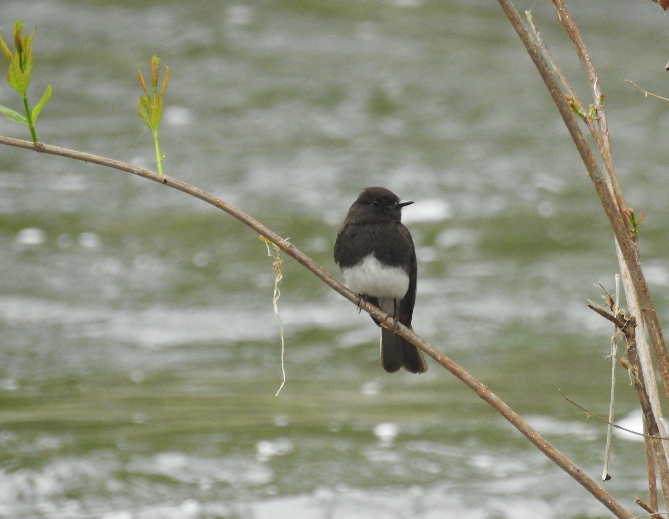
Before hitting the road, Pat has a few chores to do to make sure the next travel day is smooth – checking tire pressure on the trailer and truck, along with torquing lug nuts on the trailer, gassing up, etc. This is usually my time to do a bit of birding. Fortunately, Henry Lake State Park, directly across from our campground, provided a great birding opportunity, even though the cloudy skies and intermittent rain did not help the photo quality.

Barrow’s goldeneye

Trumpeter Swan On Nest

Audubon Warbler (a yellow-rumped warbler, affectionately known as a Butterbutt by birders)


White-Crowned Sparrow ( She had built her nest on the rocky ground!)

Swainson Hawk

Northern Flicker, Red-shafted

We did get enough decent weather to see a lot of Yellowstone, but some of the roads were still closed from winter snows. A return trip might be in order, but for now it was time to hit the road to Montana to see old friends and stash the trailer for a couple of months

Bison at Play


Spring Trip, Part 6: Yosemite, Our Own Notre Dame

by Dahna Branyan

“It was like lying in a great solemn cathedral, far vaster and more beautiful than any built by the hand of man.” – Theodore Roosevelt 

The next leg took us uneventfully back down to the valley through the orchard country of Fresno and Merced, and then as we headed back up into the Sierras, destiny, in the form of Apple Car Play, took a hand.  Siri sweetly guided us to an old logging road sporting a “road closed sign” where a woman rancher happened to be repairing a fence. We explained our Siri problem and asked if the road was really closed. She said it was open, but there were low spots that might still have water. She hesitated before saying that yes, that from there it was the road to Groveland, near our campground. We cursed Siri for the next ten miles as we rattled and rolled down the forest service road to the connecting highway. Again Siri told us to take Old Priest Road up to Groveland, CA and our campground. This time we ignored Siri and took New Priest Road instead, giving her a piece of our mind about her routing judgement. It was a steep grade zig-zagging  to the top. Pat got a bit worried when the transmission started heating up so we used a few pullouts to let it cool down a few minutes before going on. Once at the top and settled into our new digs, we found we were right to ignore Siri since RVs and travel trailers were not allowed on Old Priest Road because it was a straight 17 % grade.  We also met a neighbor who burned up his transmission on the new road, proving again that Pat is a pretty smart fellow for letting the transmission cool on the way up.

Mountain Dogwood
Mountain Dogwood


We still had to climb further up the Sierras before descending down into Yosemite Valley the next day. It was not as arduous as the roads into Groveland or Sequoia, but what a lovely drive through the evergreen forest, dotted with mountain dogwoods and manzanita. The curves were alternately punctuated with luscious waterfalls and breathtaking views of the valley below, including previews of El Capitan and Half Dome in the distance.

First Look at Yosemite Valley and Merced RiverDSCN0804

Greenleaf Manzanita (Arctostapylos patula)
ManzanitaGL.jpg

The Valley AwaitsDSCN0710


It is easier to feel than to realize, or in any way explain, Yosemite grandeur. The magnitudes of the rocks and trees and streams are so delicately harmonized, they are mostly hidden. John Muir


Muirishview.jpg

But only from the valley floor can you glimpse what Muir was talking about.  The interplay of the valley’s granite walls with the fast moving Merced River and the beauty of the diverse foliage is sublime. If one can filter out the cars and people, it takes little imagination to see this  beautiful rugged valley the way the native Awahneechee saw their home, Awahnee (translated as “gaping mouth”).  It’s hard to say if they named it after the geology of the valley or their initial reaction to the magnificent valley. Well, that was our reaction anyway. 

El Capitan, Its Heart Exposed
HeartofElCapitan

Merced River
DSCN0769.jpg

Yosemite Falls
Yosemite Falls

The Majestic Half Dome
DSCN0761.jpg

We were very happy campers coming back home to Yosemite Pines RV Resort. Our neighbors, Gary and Shelley from Whittier, CA had just returned from Hetch Hetchy  so we sat out with drinks and talked about all we had seen. When they mentioned Whittier, Pat remembered it was Nixon’s home turf. Turns out, Gary is related to Nixon on the Milhous side of the family. We had a great time visiting with them. They had recently retired from running a family seafood business. I wish we could have visited longer – I might have been able to talk them out of a recipe or two. But they were leaving the next morning and we were headed back to Yosemite, this time to see Hetch Hetchy ourselves.

John Muir and the Sierra Club fought from 1901 to 1913 to save the Hetch Hetchy Valley, lying within Yosemite National Park, from a dam that the City of San Francisco wished to build within Yosemite, arguing that there were better alternatives. As he wrote in Yosemite

“Hetch Hetchy Valley, far from being a plain, common, rock-bound meadow, as many who have not seen it seem to suppose, is a grand landscape garden, one of Nature’s rarest and most precious mountain temples. As in Yosemite, the sublime rocks of its walls seem to glow with life, whether leaning back in repose or standing erect in thoughtful attitudes, giving welcome to storms and calms alike, their brows in the sky, their feet set in the groves and gay flowery meadows, while birds, bees, and butterflies help the river and waterfalls to stir all the air into music—things frail and fleeting and types of permanence meeting here and blending, just as they do in Yosemite, to draw her lovers into close and confiding communion with her.”

They lost that battle  and the city built a dam impounding the Tuolumne River to supply the city with water and electricity. The beautiful valley was lost.

O’Shaughnessy Dam and Hetch Hetchy Reservoir
HH3Dam

But after visiting Hetch Hetchy, I feel somewhat conflicted. Yes, the beautiful valley was lost, but there is still a certain rugged beauty in the reservoir against the stone walls. There are still quiet trails to explore and a few primitive campgrounds. It is not congested with cars and tourists tramping over everything like Yosemite Valley experiences daily. Relatively few people visit. Who is to say what is the greater harm?  By all accounts, the amount of sediment that has covered the valley floor is negligible. Perhaps one day, the proponents of restoring Hetch Hetchy will win or the dam will fail (it has been there for a hundred years now.) and a restored Hetch Hetchy may end up less damaged than what has been done to Yosemite Valley.

Hetch Hetchy Reservoir
HH1

California Indian Pink (Silene Californica)
California Indian

We ended our Yosemite visit with a trip to the Mariposa Sequoia Grove, one of three groves of giants within the park. Stopping  off at the Wawona area to visit the interpretive center and the Big Trees Lodge (formerly the Wawona Hotel) , built in the 1850’s,

Big Trees Lodge
BigTreesLodge.jpg


A thunderstorm erupted during our visit and prevented us from seeing the full grove and some of the named trees, like the Grizzly, but it was still awesome to stand among the giants.

DSCN0815

A Fallen Monarch On A Rainy Day
Fallen Giant

Dark-eyed Juncos
DSCN0339.jpg

Spring Trip, Part 5: In The Land Of Giants

By Dahna Branyan

Journeying north from Yucaipa, we drove through the corporate fruit basket of the west. Mile after mile of orchards – mostly oranges, lemons and olives. Just add water to California’s famed golden hills and it turns into big ag’s version of the Garden of Eden. We stopped in a small village outside of Sequoia National Park, Three Rivers, California, named for the convergence of the three forks of the Kaweah River. We camped beside the North Fork of the Kaweah at Sequoia Ranch RV Resort. 

Fisherman On The North Fork Of The Kaweah River
 

This charming park was shaded with Valley Oaks, sycamores and western cedar. The campground was lousy with  Acorn Woodpeckers taking advantage of the bounty of Valley Oak acorns. You don’t think of woodpeckers as being noisy birds until you are awakened to the sound  of over a hundred of them Ker-racking to one another at first light. I’m pretty sure Ker-rack translates as “stay away from my acorns, Redhead.” But hey, we were here to see trees.

Acorn Woodpeckers

Every tree in the park had become a repository for the season’s acorn stash.


“Do behold the king in his glory, King Sequoia. Behold! Behold! seems all I can say…. Well may I fast, not from bread but from business, bookmaking, duty doing & other trifles…. I’m in the woods woods woods, & they are in mee-ee-ee…. I wish I were wilder & so bless Sequoia I will be.” ~John Muir

Sequoia Park literature recommended vehicles longer than 22 feet not attempt traveling the road closest to our campground into the visitor center due to the steep and winding entrance. Okay. Since we were just under 22 feet, we drove the very long winding road up to King’s Canyon National Park the first day to visit with General Grant before we attempted the more direct route up to Sequoia National Park.  General Grant, even after suffering damage to his canopy, did not disappoint at a height of 278 feet and a circumference of 107 feet, it’s easy to see why these trees were named Sequoiadendron giganteum. General Grant’s lesser foot soldiers were nearly as impressive. 

General Grant

A Few of General Grant’s Foot Soldiers


A Fallen Monarch


We didn’t expect large crowds at this time of year. Many of the park roads were still closed for snow and the kids were in school. We failed to account for the horde of selfie-stick wielding foreign travelers. From the sound of the chatter around us, the Russians and Chinese have plenty of our dollars to spend seeing the wonders of this beautiful country.  If only we had the concession on CruiseAmerica ’s RV rental business.


As it turned out, the road to King’s Canyon was pretty danged curvy. With that under our belt and after talking to our neighbor who’d already driven into Sequoia in a similar truck, we ventured up the hairpin-curved highway to Sequoia to visit General Sherman. Arriving at the parking lot to see the general, you see the giant standing right in front of the museum. Oh wait, that’s not General Sherman, that giant is The Sentinel, which the sign explains that although the tree is 2,200 years old, it is just an average sized specimen in this grove. It definitely looked above average to us. The general’s grove was a few miles up the road.

The Sentinel

 The hike to see the general was a mere half mile straight down – the easy part. Knowing that all the folks with better knees passing me on the way down would still be there mouths agape taking in the tree, I stopped short and viewed it from the “back” trying to imagine what it would have been like to wander through these woods  a few hundred years ago and happen upon an unmolested grove of giants. Apart from their size, the luster of the reddish-gold bark and the emerald green foliage atop sets them apart from the rest of the forest trees. With the sun’s rays filtering through the undersized canopy, the giants seem a bit unworldly.  Trudging back up that steep hill to the visitor center, the crowd seemed subdued and reflective to have stood in the presence of a living fossil, perhaps wondering at all these trees had witnessed. 

General Sherman on Approach

General Sherman Clip

Necks stiff from looking up at trees and Pat’s shoulder sore from maneuvering the tight curves for two days, we spent the next day catching up on laundry and resting. Of course resting involves bird-watching for me. Once you quit jerking your head around at the Acorn Woodpeckers, there were actually quite a few other interesting birds hanging around the river.

Bullock’s Oriole –  With an orange orchard just across the road I expected to see a lot of orioles, but this fellow was the only oriole I saw on the campground side of the street.

I love the way this Black Phoebe looks like our Eastern Phoebes putting on the Ritz in a tuxedo.

Ash-throated flycatchers migrate from the Pacific slope of Mexico and Honduras up to their spring breeding grounds, often in California.

 Red-shouldered hawks feed mostly on small mammals, amphibians and reptiles. This one was in a good feeding area where gophers and blue belly lizards are plentiful.


Blue Belly Lizard


The next day we checked out Lake Kaweah, a large catchment for melting snowfall and rain from the Sierras and transported by the Kaweah River. It was built by the Army Corps of Engineers both as a flood control and irrigation for the orchards.


After listening to wild turkeys call all during our stay, I took Sacha on a walk before we loaded up to move on. I could hear the turkeys on the river so Sacha and I headed that way. The hen flew across the river, but when the tom saw Sacha, he stood his ground and put on a full display as a warning. I took this shot as we turned away and hit the road.